Mount St. Helens
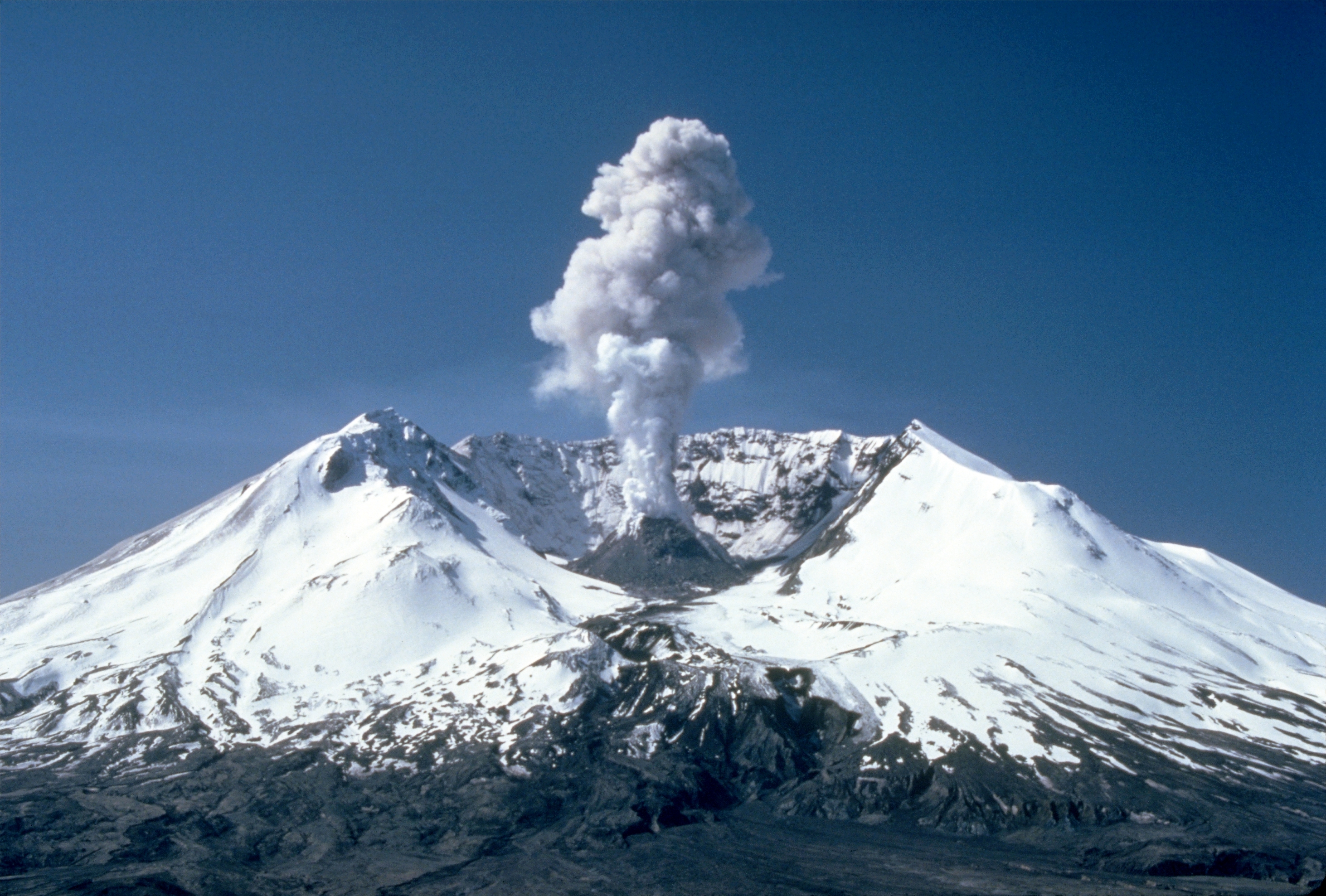
Photo: Lyn Topinka, Public domain, via Wikimedia Commons
Mount St. Helens is an active stratovolcano rising 8,363 feet (2,549 meters) above sea level in southwestern Washington state, part of the explosive Cascade Volcanic Arc. The mountain dramatically transformed on May 18, 1980, when a catastrophic eruption reduced its elevation by over 1,300 feet and created a distinctive horseshoe-shaped crater nearly one mile wide. Known to the indigenous Cowlitz people as Lawetlat'la and to the Klickitat as Loowit, this volcanic peak sits 52 miles northeast of Portland, Oregon. Today visitors encounter a landscape of remarkable geological recovery, where nature has reclaimed much of the devastation from what remains the most economically destructive volcanic event in U.S. history.
Timeline
Mount St. Helens begins major eruptive period based on geological evidence
George Vancouver names the mountain after British diplomat Baron St Helens
Catastrophic eruption kills 57 people and destroys 200 homes, triggered by magnitude 5.1 earthquake
Mount St. Helens National Volcanic Monument established by Congress
What the Show Claims
- ›Mount St. Helens is at the center of famous UFO sightings and represents a major hotspot for UFO activityS21E06S21E10
- ›The volcano is associated with extraterrestrial phenomena and high-strangeness eventsS21E06S21E10
What Archaeology Says
The Mount St. Helens region contains extensive evidence of Native American habitation spanning thousands of years, with archaeological sites in the surrounding areas revealing sophisticated indigenous cultures that witnessed and recorded volcanic activity through oral traditions. The Cowlitz, Klickitat, and other regional tribes developed rich mythologies around the mountain, often describing it as a powerful spiritual entity capable of great destruction and renewal.
The 1980 eruption created an unprecedented natural laboratory for studying ecological recovery and geological processes. Scientists have documented how the massive debris avalanche of 0.6 cubic miles fundamentally altered the landscape, while also revealing previously buried archaeological deposits in some areas. The eruption's effects on regional ecosystems provided insights into how ancient peoples might have adapted to similar volcanic events throughout the mountain's active history.
Geological research has established Mount St. Helens as one of the most active volcanoes in the Cascade Range, with a documented eruptive history spanning approximately 40,000 years. The mountain's current configuration, shaped by the 1980 eruption, continues to evolve as lava domes grow and shift within the crater. What remains genuinely intriguing is how indigenous oral histories seem to preserve accurate accounts of major eruptions from centuries past, suggesting sophisticated knowledge systems for recording and transmitting geological events across generations.
Mysteries & Fun Facts
The 1980 eruption was triggered by the largest debris avalanche in recorded history, moving at speeds up to 150 miles per hour
Mount St. Helens lost 1,314 feet of elevation in the 1980 eruption, changing from 9,677 to 8,363 feet tall
The eruption disrupted terrestrial ecosystems but greatly benefited aquatic life, with ash-enriched lakes supporting rapid biological multiplication
Indigenous names for the mountain include Lawetlat'la (Cowlitz) and Loowit or Louwala-Clough (Klickitat), reflecting deep cultural connections
Planning a Visit
Mount St. Helens National Volcanic Monument offers multiple visitor centers and hiking trails, with the Johnston Ridge Observatory providing spectacular views directly into the crater. The area is generally accessible year-round, though winter conditions can limit access to higher elevations and some facilities may have seasonal closures.
Portland, Oregon, approximately 52 miles southwest
Late spring through early fall offers the best weather conditions and full facility access, with July through September providing the clearest mountain views. Winter visits can be rewarding for those interested in dramatic snow-covered volcanic landscapes, though some roads and trails may be closed.
Related Sites
Tunguska explosion site
Both sites represent locations where dramatic natural events intersect with unexplained phenomena and UFO reports
Mount Denali
Another prominent North American mountain peak associated with mysterious sightings and indigenous spiritual traditions
37th Parallel (Global UFO Superhighway)
Mount St. Helens sits near this alleged corridor of increased UFO activity across the American West
Also Covered In
Featured In2 episodes
Historical data sourced from Wikipedia